ILSOYADVISOR POST
Brazil Drought Impacts Soybean Production
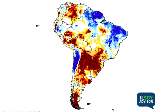
Early season drought issues across Southern Brazil (Mato Grosso Do Sul, Parana, and Rio Grande do Sul) robbed Brazil of a record setting soybean crop for the 2021-22 growing season. Stagnant high-pressure plus a lack of cold fronts moving north out of Argentina led to about 40% of Southern Brazil’s soybean growing area receiving less than 60% of normal rainfall through late January. The Parana River, which runs through Southern Brazil and joins the Paraguay River before draining into the Atlantic through Buenos Aries, had several points where the average river depth was below 3 feet. This not only slowed or stopped barge traffic, but NDVI imagery revealed that much of the river basin had very stressed crops. Figure 1 shows NASA’s Root Zone Soil Moisture measurements from January 17 when Southern Brazil, Paraguay, and Argentina were at the peak of this drought. Heavy rains over the last month have broken the drought, but too much damage was done to recover yield loss. Drought likely reduced total production 20-25 million metric tons (~15%) in Brazil.
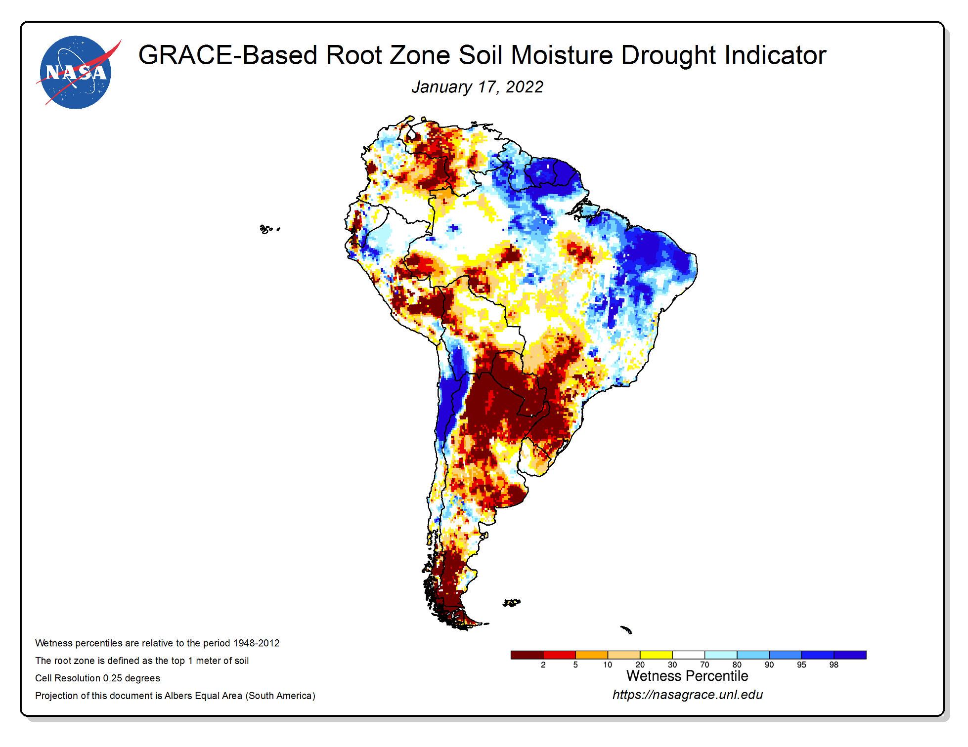
Figure 1. NASA GRACE-Based root zone soil moisture (%) from January 17, 2022. Source: https://nasagrace.unl.edu/Archive.aspx
US Drought Grows this Winter
Drought expansion this winter throughout the Great Plains and Midwest is front of mind for most growers going into the 2022 season. Figure 2 shows the US Drought Monitor from March 17, 2022 when over 70% of the land area in the lower-48 was covered in some form of drought. Drought area expanded in the Plains this winter due to a lack of southwest jet stream flow which has largely been blamed on this winter’s La Niña in the Pacific Ocean. La Niña events are known for causing a highly variable Pacific jet stream which prefers to enter the US from the Pacific Northwest and then dive into the Plains with dry, cold air before turning back toward New England. The result is often expanding drought across the western soybean belt while the eastern soybean belt, from the MidSouth through the eastern Great Lakes, is typically too wet. To erode this drought ahead of planting, we need deeper troughs digging into the 4-corners states so that the jet stream flow comes out of the southwest from New Mexico to New York. That flow pattern opens the Gulf of Mexico to better moisture transport which leads to better spring rains and a shrinking drought.

Figure 2. US Drought Monitor on March 17, 2022. Source: https://droughtmonitor.unl.edu/
La Niña and Spring and Summer 2022
La Niña has been very slow to fade this late winter despite early predictions of a fast retreat after mid-January. A second resurgence of strong trade winds in the Pacific in March knocked ocean temperatures back down prolonging the influence of this La Niña on the Spring weather patterns. As we think about the next 7 months, nearly all global forecast models are predicting ENSO-neutral conditions this summer except the CFSv2 (a US model) that continues to show weak La Niña conditions through Fall 2022. Figure 3 shows Columbia University’s outlook for ENSO through Fall 2022. They are predicting roughly equal chances of ENSO-neutral and La Niña conditions through summer with a 25% chance of El Niño developing by late fall. Figure 4 shows the latest long-range forecast for spring and early summer 2022. Nearly all long-range forecasts keep the drought west of the Mississippi River while the eastern soybean belt likely has tight planting windows and above average rainfall.
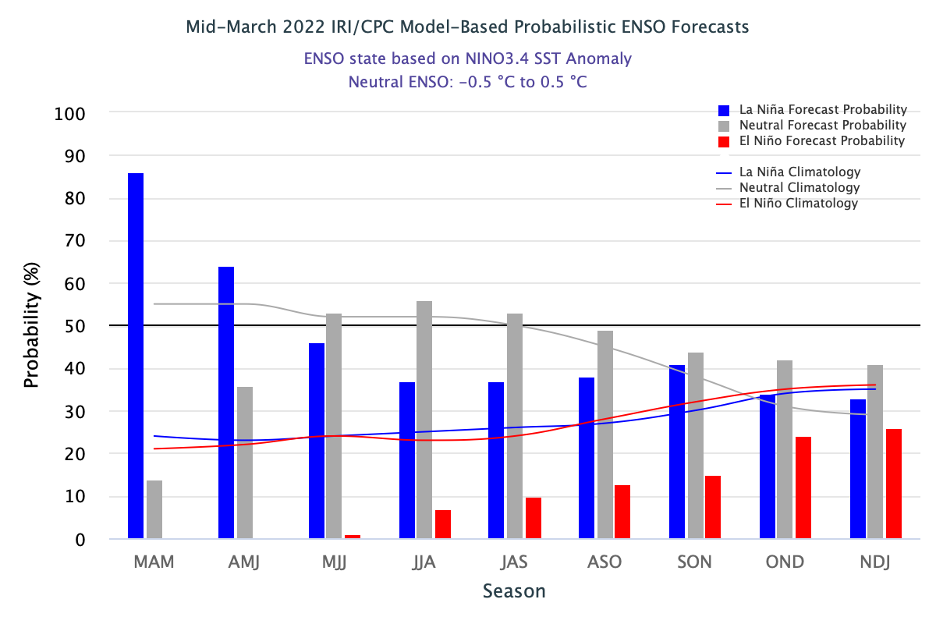
Figure 3: Probabilistic 3-month ENSO forecast March 2022 – January 2023 from the International Research Institute at Columbia University. Source: https://iri.columbia.edu/our-expertise/climate/forecasts/enso/current/
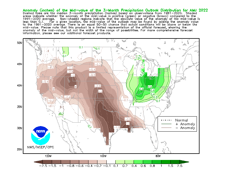
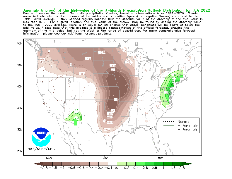
Figure 4. NOAA 3-month Precipitation Outlook for April-May-June 2022 (top) and June-July-August (bottom). Source: https://www.cpc.ncep.noaa.gov/products/predictions/long_range/poe_index.php?lead=1&var=p

.png)
Comments
Add new comment